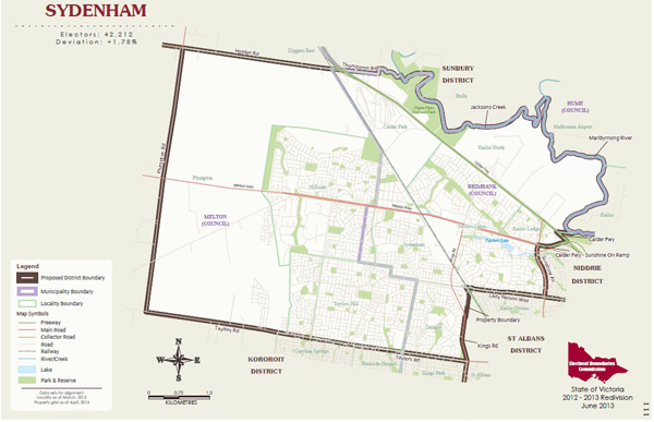
A PROPOSAL to re-draw the state’s electorate boundaries would put areas named after Sydenham and St Albans on the map.
Victoria’s Electoral Boundaries Commission (EBC) last week released new draft state electoral boundaries for public comment.
The re-division has reviewed the borders of all 88 Legislative Lower House electoral districts and eight Upper House regions.
In the EBC report, the electorates of Keilor and Derrimut would be replaced by two new regions, St Albans and Sydenham.
The EBC draft would replace the Derrimut electorate with a new St Albans district.
“St Albans is an important centre that has long been divided between various districts, and this re-division offers the opportunity to create a more coherent district centred on St Albans,” the report said.
The district would include large areas of the present Derrimut and Kororoit areas, plus Kealba, Keilor Downs and part of Sunshine.
The existing electorate of Koroit would lose St Albans if the EBC plans are adopted, but gain Cairnlea, the suburb Derrimut and the balance of Deer Park from the Derrimut electorate.
The new Sydenham electorate would include all or parts of Delahey, Keilor North, Keilor Lodge, Sydenham, Taylors Lakes, Calder Park, Taylors Hill, Hillside and Plumpton.
Also in the changes, the Niddrie electorate would take parts of Keilor and Taylors Lakes from the present Keilor district.
The electorate of Footscray would incorporate Sunshine West under the plan.
The proposed boundaries can be downloaded from ebc.vic.gov.au and are also available for public inspection at municipal council offices.
Any person or organisation may lodge a written suggestion or objection about the proposed boundaries with the EBC. The deadline for suggestions or objections is 29 July 2013.
The EBC will take account of suggestions and objections and prepare final boundaries by early October 2013. These boundaries will take effect at the 2014 state election.


